
| In support of my webspace rental fees pllease donate generously at PatreonThank your for visiting.
If you enjoy this site please make a donation. |
The Golden Mile |
|
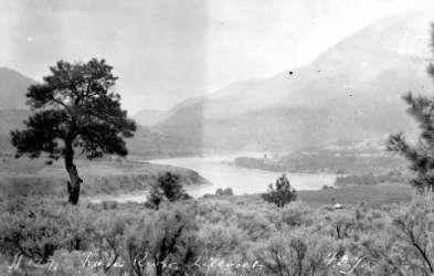
 BC Archives # A-09064 |
This is one of the oldest pictures of Lillooet, from 1864, after the town's busiest earlier years whem most gold-seekers were thronging the Cariboo goldfields and making Barkerville what Lillooet had been a few years before - the largest town west of Chicago and north of San Francisco. Lillooet remained important as a seat of government land offices and retailers and other services who had established themselves stayed on to serve the far-flung ranchers, prospectors and other settlers from the surrounding hundreds of miles of bush, as well as the region's still-numerous native people. Lillooet owed its prominence to the Douglas-Lillooet Trail, also known as the Lakes Route, which began at the head of river navigation at the north end of Harrison Lake, and from there involved a chain of portages and rough-hewn "roads", finally beaching a few miles from town at the foot of Seton Lake, then following a wagon road through the huge gorge then known as Nkoomptch, the south wall of which forms the background to this picture - it still looms impressively over town since while men come and go, mountains just do not, and is situated at a certain angle to the valleys westward that for much of the year it is illuminated by the red-gold of the setting sun while the town is in shadow, and even Fountain Ridge (across the river and out of view to the left) is only partly illuminated - because of the same gorge, which allows the sun's rays to pierce the mountain wall flanking the Fraser's west side in this area. Please visit the webpage dedicated to the Golden Mile, as Lillooet's Main Street depicted here was known in its glory days. |
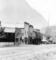
| The Phair
family residence (today Miyazaki House)
was not built yet at the time this picture was taken - it would be
on
the lane at right about where the second group of buildings are.
The small houses to the left of Main Street, on the lip of the bench,
are part of Chinatown, which like the
rest
of town grew busy again with the onset of the Cayoosh gold rush from 1884 onwards
until
the Golden Cache boom of 1898. The
influx of hundreds of Chinese in the 1880s launched a market-gardening
industry which thrived for decades after. A 1920s
picture on the page devoted to the Golden Mile
shows the lush gardens of Chinatown on
the
lower benchland between Main Street and the Fraser. During
gold rush years, the barren spaces surrounding this small commercial
strip (very big by the standards of BC in the 1860s, however), was
covered in tents and temporary structures to house the tens of
thousands
of men who had chosen to come to the upper Fraser, since the lower
Fraser goldfields had been staked out early on in the rush. As is
the way of gold-seekers throughout the history of the North American
gold rushes, the horde of prospectors (and those who took advantage of
them) moved on north when word came out of even richer finds in the
Cariboo. |
|
The Mile 'O' Cairn |
|
 BC Archives # I-22310 |
The Mile 'O'
Cairn stands at the apex of the bend in Lillooet's Main Street,
adjacent
to the survey marker that marked Mile 'O' of the Cariboo Wagon Road
that led from Lillooet to Barkerville. Due north from this point,
Lillooet's Main Street ran wide enough to turn a draw of oxen in - the
famous "Golden
Mile" - along which stood
hostelries, saloons, stores, restaurants, and the innumerable other
services that were necessary along the staging ground of a frontier
wagon road. From this marker were measured all the mile-points of
the wagon road, including the names of such towns as 70 Mile House and
100 Mile House (although the popular misconception is that these were
measured from Yale on the Fraser Canyon route).
The cairn was built of local ores as part of the celebrations of the
1958 Centennial of the founding of the Mainland Colony (as the Crown
Colony of British Columbia is called; the Island Colony, or the Colony
of Vancouver Island was formed in 1849). The object on its top is
actually a light-socket, which I believe was intended for Christmas
trees and other electrical fixtures, but I don't think it's seen much
use in the years since the cairn was put up (if I recall, it was my Dad
who did the wiring for it, by the way). The mountain in the
background is the eastward flank of Mt. McLean, the summit of Mission
Ridge. The Lillooet
Library and a medical clinic now stand in the open space behind the
cairn in this picture; immediately across the street is the Lillooet
Museum. |
| The Hanging Tree | |
 BC Archives # H-02884 |
The
Hanging Tree is one of Lillooet's most famous sights, and is rich with
legend as this 1910s image of it suggests. A wind-twisted and
incredibly gnarled and ancient ponderosa pine, it still stands on the
benchland just above the Golden Mile in
what
is now Cayoosh Park, although it is now surrounded by younger pines -
as
well as one of Lillooet's many modern subdivisions. It's also dead, although efforts have been
made to preserve it despite a couple of fires which nearly destroyed
it. To reduce the fire hazard, the dead tree was "pruned" as can
be seen on a separate webpage dedicated to it on this site.
Although there were hangings
in
Lillooet in the old days, there's no proof they were conducted from the
Hanging Tree, despite its name and the fact that, as one old-timer put
it to me, "if you were gonna hold a hangin', that's for sure a tree
you'd think about usin' - and a damn pretty view for the one bein'
hanged to see". Cayoosh Park is also the site of the Chinese Rock
Piles, in which one of the tree's many legends says the bodies of those
hanged were thrown, as well as disused outdoor checkerboard, a
playground, and a dirt BMX track for the neighbourhood's many kids. |
The Royal Engineers Bridge
|
|
 Photo: Mike Cleven |
This
1912 suspension span is not the first bridge at this site, but replaced
an older truss span also built by the Royal Engineers which itself only
went up in the 1890s; pictures of that older bridge and more of this
one
have their own page. Before that,
wagon and stage traffic to the east side of the Fraser and the
northbound Cariboo Road and the southbound Lillooet-Lytton
Road used either a tollbridge at the Bridge
River Fishing Grounds or Miller's Ferry, which was just downstream
from this spot at the outlet of Lillooet
Canyon. The ferry was operated by a German immigrant, John
Mueller, and was of the "friction ferry" type - a barge attached to
cables which was pulled across the river by the force of the
current. The bridge here remained the main road access to
Lillooet
until very recently, when Hwy 99's Bridge of the Twenty-Three Camels
near Cayoosh Creek was opened. A
tribute to the engineering skills of the Royal Engineers, the Old
Bridge
saw years upon years of heavy truck traffic traffic and yet still
stands
today. It is now closed to vehicular traffic but is open to
pedestrians and bicycles. Interesting to visit in its own right,
there are many fishing platforms and drying racks right by the bridge,
as well as a picnic site and an impressive view up the Fraser towards
the PGE bridge and the last peaks of the Camelsfoot Range. |
"The
July"
|
|||
|
|||
| Horseracing
was by far the most popular and competitive sport in the whole of
British Columbia in those days,
with the races in Lillooet and horses from local ranches attracting
major betting interest in Vancouver, New Westminster, Victoria, and
even
Seattle, Portland and Spokane. Competiton was stiff, and the
betting was big-stakes. Many
Interior ranches, including the Jones
Ranch just south of town, built
their reputations and their wealth on the quality and winnability of
their horseflesh, to the point where horsebreeding (and gambling) were
a
major cashcow of the local economy. The races at The July
were among the most prestigious and well-attended in the Interior, and
it's safe money that a lot of the hats in that crowd are on the heads
of
bettors from the Cariboo or the Coast who came to the July for this particular race. A
little
diggin' in the Museum's archives I could probably find out who the
horses and riders and their backers were, and how much money turned on
the outcome! |
|||
|

|
|||||
Tobacco Farming |
|

BC Archives # A-03547 |
Tobacco
farming was one of Lillooet's many "lost industries" - locally-based
industries from an age in which the town had a very diverse economy -
which included market gardening, orchard produce, and the Fountain Ridge ice caves, which supplied
high-quality bubble-free ice to Vancouver's best hotels in the days
before motorized refrigeration, as well as an impressively-productive
market-garden produce industry instigated by Lillooet's once-numerous Chinese. The tobacco
farms were such a success the
town for many years had its own
homegrown brands which were marketed
throughout Western Canada. Legend has it that the first tobacco
in
Lillooet was planted in the gold rush by the many Mexican packers who
worked the Cariboo Wagon Road and other routes, and also inroduced the
use of adobe in local
construction. it was Kentuckian Jonathan Scott (see below) who
turned it into a commercial enterprise, however, producing plugs of
"chaw" for gold rush-era miners from the US. The benchland at
upper centre is the location of
today's Conwayville neighbourhood and the back end of the BCR railyards. This 1890s picture
pre-dates
the railway, which at first ran through this same area, and later
across
the sandbank at upper left. |
| Grave of Jonathan
Scott, Tobacco Farmer |
 BC Archives # I-29069 |
| The BC Archives credit for this photo says "Indian Grave, Lillooet" but this is incorrect - this is actually the grave of Jonathan Scott, one of the main founders of Lillooet's once-prosperous tobacco industry, as described in Mrs. Edwards' book on Lillooet's history. Indian graves and cemeteries have a different look to them, and are usually on Indian Reserve land, which this is not. The site of this grave is on the benchland just above the old Royal Engineers Bridge, which was also the location of Scott's tobacco fields Scott was a Kentuckian who became one of the main tobacco entrepreneurs in Lillooet, and employed 50 native people in the course of supplying chewing tobacco to the many American miners in the district "who were missing tobacco more than their women". The same benchland is now the site of one of the Lillooet area's many modern-day ginseng fields. |
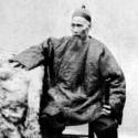
The Chinese in Lillooet |
|
 BC Archives # C-01280 |
Lillooet's
Chinese citizenry were an
important part of its history and some of the main movers and
shakers of its economic life right up until the Second World War.
The montage of locals at left was assembled by Artie Phair and probably
includes many of the more notable local Chinese businessmen and
settlers, whose descendants have now mostly relocated to the Coast or,
in some cases, back to China. For more details on the history of
the Chinese in Lillooet and their huge role in local gold mining and
merchant businesses, please see the Chinatown
page. |
Chinese Rock Piles |
|
`````````````````````````````````````````````````````````````````````````````````````````````````````````````````````````````````````````````````````````````````````````````++` Photo: Mike Cleven |
"Chinese
Rock Piles" are found all over the Lillooet district, but a group of
three such piles - pits actually - in Cayoosh Park, on the benchland
just above the courthouse and near the Hanging
Tree, have been marked and designated heritage sites. These
rock piles (or pits) are the remains of Chinese reworkings of previous placer operations - the Chinese miners would
take the discarded tailings and wash the rocks by hand, scrubbing them
clean and then panning the residue of sand and silt - often earning
more
this way than non-Chinese miners had earned in the original workings
than produced the tailings. Chinese mining operations were
extremely thorough - along Cayoosh Creek, which Chinese miners worked
near-exclusively from 1884 to the mid 1890s, silt and gravel was dug
and
upturned to the bedrock, often over 30 feet from the surface, and all
rocks dug up were thoroughly scrubbed to get all traces of gold dust
and
gold-rich black sand off them - and to inspect them to see if they were
jade or another semi-precious stone such as agate. For more pictures of the Chinese rock piles
and history of the Chinese in the Lillooet Country, see the Chinatown page. |
Ginseng |
|
 Aerial pic from Photos by Kat |
Ginseng
has and merchant become one of modern-day Lillooet's most important agricultural
crops, thanks to rich alluvial and volcanic soils, torrid heat, and
lots
of vacant land. Ginseng fields, which are now fairly common
throughout BC's dryland districts, have to be shaded as well as heavily
irrigated to create an artificially humid environment, so in order to
grow them in the Lillooet area fields are covered in sun-shading but
heat-collecting plastic sheeting, such as this one immediately across
from town at the base of Fountain Ridge.
More on Ginseng is on the Chinatown
page. This particular set of fields is on the site of one of
Jonathan Scott's former tobacco plantation, which received water via a
flume built for washing gold from the benchland; the flume ran around
the flank of the mountain from Fountain, some eight miles, and was
built by Ah Key, a local miner. |
Dickie Creek and Lillooet Honey |
|||
|
|||
 |
 BC Archives # B-02677 |
 BC Archives # F-03511 |
 |


