
Photo: Mike Cleven
BC Archives # G-00808 (Photo: Charles Gentile, 1865)

Aerial pic from Photos by Kat


Aerial pic from Photos by Kat


| Photo: Mike Cleven |
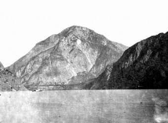
BC Archives # G-00808 (Photo: Charles Gentile, 1865) |
| A couple of views of the Lillooet end of Seton Lake, once known in the St'at'imcets language as Skimka ("otter"); the picture on the left is my own; that on the right from the BC Archives.. As with other pictures of this country, the impact of the setting is hard to convey from one camera angle; the huge bluffs of McNeils are immediately up to the left, and a sheer rock wall some 2500 feet high plunges directly into the water just behind the camera and to the right. The mountain in the centre of this view is actually a shoulder-flank of 9890 ft. Mt. Brew, which is behind the dark slope on the right, which also conceals the last gorges of the Cayoosh Canyon. Cayoosh Creek flows behind the terminal moraine in the centre of the picture to merge with Seton Creek off to the picture's left. At that point, the rock walls of Mission Ridge and the montane cliffs of this picture close in to form the gorge called Nkoomptch, which may only be half a mile or so in length and less than that in width but measures around 6000 feet in depth; (invisible in the shadows at left in the first photo) are the immense overhangs a couple of thousand feet up the mountainside above the canyon floor; they are hinted at in Gentile's 1865 photo at right. The shoreline in this picture is "the beach" to Lillooet residents, the left half being managed by the Lillooet Band and the right half taken care of by BC Hydro, as Seton Lake is one of the reservoirs of the Bridge River power project; there is a free public campground in behind the hill along the foreshore. | |
Aerial pic from Photos by Kat |
|
| lake_train.jpg |
|
Aerial pic from Photos by Kat |
|
|
|
|
|