In support of my webspace rental fees pllease donate generously at GoFundMe or Patreon
Thank your for visiting.  If you enjoy this site
 please make a donation.

Aerial View of Lillooet looking WestA Very Short History of Lillooet


Now where the heck is Lillooet, anyway, and why should you care?

Well,  you don't have to care, but since you're here anyway you might as well know that Lillooet is about 150 miles northeast of Vancouver, and about 80 miles northeast of the much-more famous ski town of Whistler.  It is located in a particularly spectacular part of the gorge of the Fraser River, just where that river starts its journey through the Coast Mountains to the Lower Fraser Valley and Greater Vancouver.  You not be interested in history at all, but Lillooet is worth a visit just for its stunning scenery and hospitable climate and beautiful mountain-desert lakes and canyons.


What's the deal with Lillooet's history?   If it was so important, why haven't I heard of it before?

Well, it's not that important - but it was the first non-native town in the Interior of British Columbia and one of the two main "urban" centres of the Fraser Canyon Gold Rush of 1858-59 (the other was Yale).  Its claim to fame from that era is as Mile '0' of the original Cariboo Wagon Road, and as the terminus of the Douglas Road or "Lakes Route" from the head of steamboat navigation at the upper end of Harrison Lake - the first major capital expenditure of the Crown Colony of British Columbia.  After the Gold Rush (er, its first gold rush - it's had eight), it dwindled rapidly but remained relatively important to a certain degree as the seat of the Lillooet Land District and the district courts, and before the 19th Century was out saw two more gold rushes and the start of a third.  It also was intrinsic to the first major capital expenditure of the Province of British Columbia, the Lillooet-Burrard Cattle Trail. which turned into the single biggest financial fiascos in the early province's history.  Despite that, the son of one of its main instigator later became Minister of Highways and Public Works (his brother was a cabinet minister, too), one of a handful of relatively illustrious provincial politicians from the area (including the province's fourth Premier).

During the 20th Century, despite relative obscurity within the public eye, it became important as the terminus and eventual section yard of the provincially-instigated Pacific Great Eastern Railway (now the BCR, which recently became part of CN) and as a supply town for the booming Bridge River Goldfields and, after World War II, for the massive undertaking of the Bridge River Power Project.  During World War II, the Lillooet Country was the site of five relocation centres for Japanese-Canadians forced from the Coast, many of whom remained after the war.  Its Chinese population has largely returned to the Coast or to China, but from the original Gold Rush until World War II it had one of the largest Chinatowns in British Columbia - many of its buildings constructed of adobe, a technique learned from the many Mexicans who were present during the gold rush.  Lillooet's merchant community had a strong Chinese component right up until the end of World War II.  It also elected the Canada's first Indo-Canadian mayor, and has been known for its ethnic diversity ever since the Gold Rush, when a complicated stew of French-Canadians, Metis, Italians, Belgians, Germans, Dutch, Scandinavians, Slavs, Mormons, Chinese, and (most of all) Americans thronged the goldfields and formed the base of the local non-native population.  The town's gold rush-era population was such that Judge Begbie could not convene a jury here, as "there were not twelve British Subjects to be found" - out of a population of some 16,000 at the time!   Until World War I, the Americans remained the most prominent non-native ethnic group in the region (i.e. though the Chinese may have been more numerous, the Americans were more high-profile), and many of the Bridge River-Lillooet Country's most famous pioneers were American by origin, although as with all other immigrant groups, those that stayed all became Lillooeters at heart. 

Among these was the town's most famous citizen, Margaret Lally "Ma" Murray of Kansas, pioneering newspaperwoman and gadfly, who was one of two Lillooeters inducted into the Order of Canada, the other being Dr. Masajiro Miyazaki, one of the many Japanese-Canadian internees located to the Lillooet area during World War II who stayed on after the war to serve as the town's and area's main physician and coroner.  It was Dr. Miyazaki who noted that, despite the town's first impression as a redneck backwater, that "you can't be a racist and stay in Lillooet for very long", i.e. because of the incredibly mixed social and family networks built into the economic fabric and daily society.  Dr. Miyazaki was also awarded a Governor-General's Medal for his work with the Boy Scouts, and it should be mentioned that, incidentally, Ma Murray's husband, longtime local MLA George Murray, had been instrumental in the founding of the Canadian Boy Scouts at the instigation of his editor at the Ottawa Citizen, who was seeking to curry favour with the then-Governor General (who was a big fan of Baden-Powell, founder of the Scouts).

Other publicly-decorated notables connected with the town are war heroes Grand Chief Jimmy Scotchman, Captain Frank Gott (who enrolled in the ranks for World War I at the age of 65), and Delina Noel, whose husband Arthur Noel was one of the codiscoverers of the Golden Cache vein on Cayoosh Creek but who, after their divorce, carved a career for herself as prospector and mine entrepreneur in her own right.  There were many other individuals of wider public note, including Curly Evans, a Dakotan whose freight business in the area became one of the province's largest transportation companies, and whose career spanned muletrains to small-plane pilot, and Charlie Cunningham, a man-about-town in the Bridge River Goldfields towns whose long and multi-hued career included some of the first major wilderness and wildlife film-making, featuring the backcountry of the Bridge River as well as other regions of the province, notably the Omineca and other areas in  north.  This is only a short list, limited to those people who were publicly decorated in some way - one trait of the region's history is that of dynamic, often infamous, individuals of all kinds; to know the history of the area is to know the history of various personalities, each in their own way as big and imposing as the mountain ranges which frame the district ("Rugged country makes for rugged people" was the way one old-timer put it to me).

The predominant population in the area are the St'at'imc (the Lillooet Nation) whose society and culture stretch back thousands of years, and they have also produced a string of well-known native politicians and other notables (including Jimmy Scotchman and Frank Gott, already mentioned).   Lillooet is reckoned to be one of the oldest continuously -inhabited sites in North America, and the fishing grounds adjoining the town are the most important on the Fraser River in the Interior, and have been "since time immemorial".  Archeological digs at nearby Keatley Creek, about 15 miles from town, date native culture in the area back at least 9,000 years, and it's a truism that much of the area's archaeological potential remains unexplored and that, in many locations where it might be most interesting to have "dug", human occupation and disturbance has been near-continuous since the time of the gold rush (e.g. at the town of Lillooet itself, or on Seton Portage, at the other end of Seton Lake).
BC Archives # A-09064 View of Lillooet 1864
BC Archives # A-09064   1864
sketch by W.S. Hatton, 1864, "Lillooet, on the Fraser"
BC Archives # pdp00070
Photograph of Lillooet, 1864 (valley of Cayoosh Creek in background)
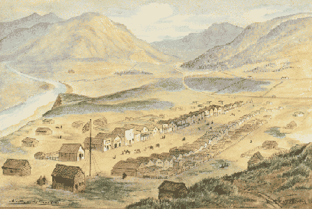
Sketch from the same year by W.S. Hatton (Fraser River at left)


Wow.  So why isn't any of this in my guidebooks to BC, or in any of the major histories of the province?

That's a good question.  Some way that Ma Murray's notorious tongue put off the politicians and entrepreneurs from doing much for the place, but it seems to be more that the published histories and guidebooks on BC focus on areas people are more likely to visit, nobody ever bothered to write much on Lillooet or the Bridge River Country and, in the tourism business, competition is competition.  For instance, web pages on Cache Creek, which is east of Lillooet about 50 miles, mention gold-panning and jade-hunting to the west, but don't even mention Lillooet by name (even though it's the larger of the two places).   Lillooet's also not identifiably in any of the "named regions" of the province, e.g. the Okanagan, the Kootenay, the Cariboo, the Thompson-Shuswap etc and, by rights, should be known as its own region.  It's always been considered part of the Cariboo, though being quite separate from the rest of that region geographically, and also part of the Fraser Canyon; but when people think of the Fraser Canyon they think of Yale and Boston Bar and Lytton, and while pictures of the Lillooet area are featured on brochures on the Cariboo, the ads and writeups are for Williams Lake and 100 Mile House.  Lately, the Whistler resort community has taken to using Lillooet as a "draw" to sell hotel rooms and tours based in Whistler, and there's been an effort to include it in the marketing-spawned "Sea to Sky Country", despite it having its own history and identity.  The environmental movement's thrown its own curveball into the equation, rebranding the northern half of the Bridge River Country erroneously as "the South Chilcotin" to the point where some people have baldly stated that Gold Bridge and even Lillooet and Shalalth - are "in the Chilcotin".   The environmental lobbyists, when discussing local scenery, point to the Stein Wilderness Park which is more connected to Lytton, and omits mention of non-park spectacularities such as the Bridge River Canyon or Fountain Gorge.

Griping and sniping aside, the major
reason may be that the difficulty of getting in and out of the place, which is off the province's main routes of travel, just kept anyone from noticing.   The Duffey Lake Road, an extension of Hwy 99 from West Vancouver and Whistler via Pemberton, was only opened in the mid-1980s, and the stretch of what is now Hwy 99 from town to the Cariboo Highway (97) just north of Cache Creek was only paved at the opening of the 1980s - the roadbed from town as far as Marble Canyon until that time being the very same as that of the original Cariboo Wagon Road!  The road from Lytton and Highway 1, Highway 12, was only paved in the mid-1970s.  Travel time to and from Vancouver back in the early 1960s was in the range of 12 hours (the train trip was less than half that, though).  Also hampering the town's profile in tourism was a lack of large-scale accommodation and services, and for many years a focus on resource industries created political and social tension relatively hostile to tourism operations and tourists, although that collection of attitudes has shifted in recent times following the closure of the town's mill and the cessation of daily passenger rail service to and from North Vancouver.

What's interesting is that, when someone does trouble to mention the town or the region around it, their reports are always glowing - colonial Governor Douglas commented that it occupied "the prettiest site for a town on the Fraser", Judge Begbie was surprised that he'd had "no previous awareness that so mountainous and desolate a country could exist in such close proximity to a major river such as the Fraser", journalist and historian Bruce Hutchison and others in the 20th Century wrote favourably of the town's agricultural productivity - particularly for orcharding - and "potential as a wine region" once irrigation was powered by the power project then under development (hay and ginseng are the main crops, however, even though this was the main wheat-producing region of BC for twenty years in the days of the colony and early province, and one of the main vegetable produce suppliers to Vancouver and the goldfields in the mid-20th Century).  Visitors to the gold mines of the Bridge River, or to the sites of the power project, , invariably extolled the special character and stunning beauty of the setting.  (The one exception was artist Emily Carr, whose coastal-oriented aesthetic could not appreciate the stark and rough desert landscapes, and whose visit to the goldfields in the '30s is marked by noticeable depression and melancholy.)

Ma Murray used to get quite incensed about it, as other Lillooeters do, when someone referred to it in negative terms as a "dusty nowhere" or in similarly disparaging terms.  Like others, she would point proudly at the hundreds of millions of dollars in gold, hydro and railway revenues contributed to provincial coffers (as also in more recent times with timber), and bemoan the lack of return on that contribution - or even of respect.


How can I find out more?

Well, this website is pretty haphazard and isn't written like a book, but with it's the closest you'll find to a comprehensive history and guide to the Bridge River-Lillooet Country.  It's arranged on various themes and tries to cover as wide a range of subjects as possible.  It began as a compilation of historical photographs from the BC Archives and the author's family collection but has expanded to include photos from other sources, including a series of stunning aerials by "Kat" (including the one at the top of this page).  Each photo comes with its own commentary on things featured in or connected to the subject of the photo - sometimes an otherwise boring-looking image actually turns out to have an interesting context, as you'll find out.  This site is by no means complete and is an ongoing work-in-progress - and corrections and contributions are always welcome.  The paragraphs above are a rough outline; details are to be found in the website's other pages.

The history of Lillooet is also inextricably linked with that of the Bridge River Country,
the neighbouring communites up and down the Fraser Canyon, and the Pemberton Valley (originally the "real Lillooet" as will be explained, but now considered part of the Sea to Sky Country marketing region dominated by Whistler).