
| In support of my webspace rental fees pllease donate generously at GoFundMe or Patreon |
Thank your for visiting.
If you enjoy this site please make a donation. |
|
 BC Archives # G-00363 |
 BC Archives # I-33349 |
 BC Archives # I-33341 |
|
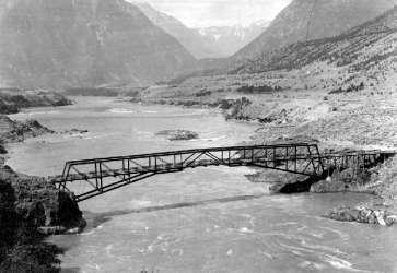
The bridge and, if it's during a salmon run, there'll probably be some people getting their fish, and those racks will be decked out with stripped and filletted salmon. ][As at the Six Mile fishing grounds at the upper end of Lillooet Canyon, a dried-out stream of desert air of just the right aridity and temperature sucks the moisture out of the fish, wind-curing it in a matter of hours on some days. Local natives also smoke salmon, and especially for double-smoking it into a kind of jerky.][ that on the left being much older and the original one at this location, which is at the outflow of the gorge of the Fraser known as Lillooet Canyon, which runs from the junction of the Bridge River at the Six Mile Rapids to where the river opens up in a broad swathe in front of town. The older bridge at left was not built as part of the original route of the wagon road, which ran to another bridge upstream (which gave the Bridge River its name), but was built in the 1870s (?) after a road was finally constructed around the flank of Fountain Ridge to connect with the route leading north from the Bridge River Bridge. The BC Archives documentation for this image gives its date as in the 1920s, but this must be in error as the "newer" suspension bridge dates from the mid-1910s. The bridge on the right, which is a cable-suspension span similar to those at Alexandria (north of Yale) and Soda Creek (north of Williams Lake) was also built by the Royal Engineers, as was so much in early British Columbia, but dates from the 1910s. It is no longer in use for vehicular traffic today, but still stands as part of a local heritage park and forms part of a walking/biking loop from town using the newer "Bridge of the 23 Camels". The rocks on either side of the bridge are part of the native fishing grounds, and the racks and scaffolding used for the native fishery are readily observable on a walk across the bridge. More pictures of this bridge from various angles follow. The horse-drawn wagon at right is the Lillooet-Lytton stage, which it is important to remember would have approached this bridge via the Fountain Valley and Fountain - rather than by the route of today's Highway 12 - because of the then-impassable Big Slide. |
|
 Photo: Mike Cleven |
 Photo: Mike Cleven |
 Photo: Mike Cleven |
 BC Archives # D-01680, Bridges at Lillooet |
 BC Archives # F-08980 |
 BC Archives # I-57554 |
 Aerial pic from Photos by Kat |
 BC Archives # I-33340 |
 Photo: E. Cleven |
 Photo: Mike Cleven |
 Aerial pic from Photos by Kat |
|
 Photo: E. "Andy" Cleven |
|