BC Archives # I-22304 |
BC Archives # F-07307 'Xwisten
|
![]() Aerial pic from Photos by Kat |
I've used the
proper St'at'imcets name for the Bridge
River out of respect for the people whose domain it is, i.e. the Bridge
River Band of the Lillooet Nation, also known
as the Xwisten People. The name properly applies to the
whole river but for purposes of this website I have used it for this
webpage, which focusses on the lowest stretch of the river which is also
the location of the main residential part of the Bridge River Indian
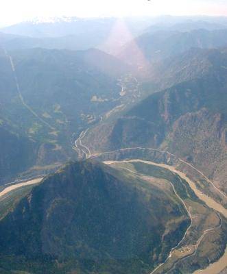
Reserve, spanning the centre of the photo at left. The Bridge
River Indian Reserve is one of the largest in British Columbia and takes
in most of the lower basin of the Bridge River below Moha. First entering the history books as "Shaw's River", after one of Simon Fraser's party, and known to the native people as 'Xwisten (sometimes spelled Nxo'isten in older maps), the Bridge River is said to have acquired its present name due to the location at its confluence with the Fraser of a now-vanished toll bridge erected by a white entrepreneur in the days of the 1858-60 Gold Rush to connect Lillooet to the northward continuation of the Cariboo Road through Fountain and Pavilion. Actually the name Bridge River was in use before then due to the location of a native-built bridge across the Fraser connecting the opposing banks of the Bridge River Rapids of the Fraser, the site of the famous Bridge River Fishing Grounds, which was torn down by the aforementioned entrepreneur in the course of removing any competition for is own expensively-tolled crossing. Until the construction of the Royal Engineers' bridge at the outlet of Lillooet Canyon, which is the river's gorge between the Bridge River Fishing Grounds and the town of Lillooet, the old toll bridge over the Bridge River Rapids was part of the route of the first Cariboo Wagon Road and around it grew a booming settlement here with several saloons and other businesses. However, quite a bit of traffic went via Miller's Ferry near the site of the Royal Engineers' Bridge due to the high tolls charged at the Bridge River. What remains of the formerly bustling gold rush town today on the same site today are the ruins of cabins that were part of a native rancherie (built in years since when native people reoccupied the site) plus the main cemetery of the Xwisten Band of the St'at'imc Nation . The location of this townsite and the old Bridge River rancherie is on the benchland to the right of the Bridge River in the pictures at the top of this page. |
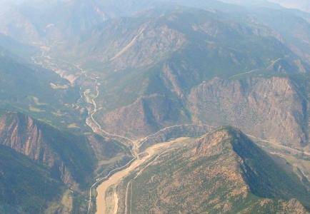
| The valley of the lower Bridge River is extremely dry and is covered mostly in pine forest, reaching nearly to the heights of the Camelsfoot Range, as depicted at right. The road in the lower left corner of this photo is now Hwy 40 but was known historically as the Moha Road, after its original destination at the confluence of the Bridge and Yalakom Rivers about 20 miles upstream from the Fraser. The modern road is not exactly the old Moha Road, of course, which was very rough and difficult driving, being originally a wagon road as with so many others in the area. The view below is of the same are, but obviously from much higher up, looking up the valley from approximately above the Fishing Grounds. The bluffs of Applespring Canyon are in the background. A similar view at lower left is taken from farther back, above Fountain, and shows the northernmost spire of Fountain Ridge as well as the second half of the double-horseshoe Great Bend of the Fraser. The Fishing Grounds are hidden just behind that last spire of Fountain Ridge. Similar views from the same vantage point follow below; actually they're the same image but some a cropped close-ups made from the others. | ![]() Aerial pic from Photos by Kat |
![]() Aerial pic from Photos by Kat |
![]() Photo: Mike Cleven |
![]() BC Archives # I-33330 Photo: Frank Swannell |
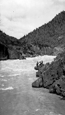
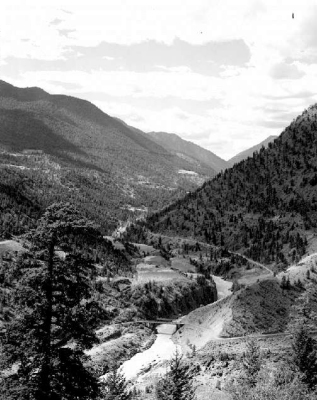
| The location of the photo at above right is
just above the Bridge River Fishing Grounds;
the much older one at above left is at the river's final outlet into the
Fraser at the Fishing Grounds and show the
full force of the river's flow before its diversion through Mission Mountain to the powerhouses at Shalalth.
As suggested by this comparison the river is a shadow of its former
self and is really little more than a trickle compared to its former
volume, as can also be seen in the photos below which are only slightly
more upstream from the location at above left. The gorge
depicted below was once roaring with one of the Fraser's
main tributary flows and teemed with a fishery now near-completely
destroyed as a result of the diversion; the extreme narrows at upper
right in the photos below would have been a gushing fountain of a
waterfall, instead of the small one seen today. |
|
![]() Photo: Mike Cleven |
|
| This is a view up to the heights of Mission Ridge from just above the
current Hwy 40 bridge over the Bridge River;
the Bridge River valley is to the right, Lillooet
to the left. Mt. McLean, the
highest of Mission Ridge's many low summits, is partly obscured by
overexposure; the powerline cut at right runs over the shoulder of the
ridge in the lea of those summits, finally reaching Mission Pass where it descends to join up
with the other high-tension lines from the Peace River Power Development
which run along the south shore of Seton Lake. |