
| In support of my webspace rental fees plleasedonate generously at GoFundMe or Patreon |
Thank
your for visiting. If you enjoy this site please make a donation. |
|
|
|
Thanks to loans of photos of the area from Randall's Flying
Photo Page taken by Randall's friend Kat on various flights
through the area I'm able to show you the scope and nature of the road
and the country it's situated in, as well as the key geographic
position it took advantage of, where the Bridge River comes close to the
Seton drainage at a relatively (!) low pass. I've never seen this
view, but it was instantly recognizable when I first came upon it.
The route the road uses is actually on a part of the mountainside
that's a bit broader and more gently-sloped than east or west of it,
which is why it's where it is - and it's not as bad as it might have
been. There are steeper roads in the district, but all of
them are backroads and none transit so much difference in elevation over
10 miles. As you look at this photo, remember that this was
originally is a pack trail that became an inecredibly busy freight route
for many years, and the communities at its bottom constituted a
medium-sized modern town, one of the largest in the Squamish-Lillooet
Regional District in fact, though unincorporated. The Shalalth
rancherie (meaning the residential part of an Indian Reserve) begins in
the fields at lower right, which are actually benchland; this picture is
looking fairly steeply down, especially given the wide-angle
distortion. The powerhouses and company townsite are themselves
actually also in Slosh Indian Reserve No. 1. In the closeupat
left and on the townsite page, the driveways to these parts of the
reserve can be seen more clearly, as well as the powerline cut, which
didn't just go to the rancherie, I think, but was the main line to
Lillooet as well. The closeup below also has a better view of the
townsite at lower right, and just below at left there is a closeup of
the pass, where the diagonal route of the Anderson Lake-Mission Ridge
powerline, the same that runs the high inside slope of Mission
Ridge.then spans the opening of the Bridge River Valley and from there
over the flank of the Camelsfoot towards Pavilion and Kelly Lake.
The scale of the photo is more impressive considering the
immensity of these high-tension lines, which come down from the distant
Peace River Country and through Whistler or the Lower Lillooet Valley to
the Lower Mainland and the US. Visibly ugly and always
environmentally controversial, the powerlines that span the
Lillooet-Bridge River are nonetheless amazing feats of engineering, and
having driven a few of the powerline roads I can tell you they're
spectacular to traverse by 4x or by bike. The 1600' difference in
elevation between the two valleys is hinted at here - the top of the
penstocks at lower left (more visible in the townsite closeup) is a
certain amount lower than Carpenter Lake, visible beyond the summit of
the pass, but not by much; total head is 1600' but from the penstocks
it's 1300' or so. The pass crests over 5000' from Seton Lake's
750' and Carpenter's 2250 (2200? Well, depends on water
conditions, really - whether the reservoir's full or not, which it often
isn't). The identical hues of the waters in the two lakes are the
colour of the Bridge River, now diverted almost wholly through to Seton
Lake but for water-releasing ordered by fisheries of late to coordinate
shared use of the river with the remnant of the great Bridge River runs
that had been among the largest of the Fraser's tributaries. |
|
|
|
 Aerial pic from Photos by Kat |
|
|
|
| |
|
 |
 |
 |
 |
 |
 |
 |
 |
 |
 |
 |
 |
| |
 |
 |
 |
 |
 |
 |
 |
 |
|
| |
 |
 BC Archives # D-05721 |
 BC Archives # I-29057 |
|
| Perhaps
no other road in the history of British Columbia - other than the
Fraser Canyon itself (but only because more people have seen it) -
has been held in such dread and awe by travellers as that running
from Shalalth over a switchbacked route known as Mission Mountain,
leading over the steep mountainside into the Bridge River Valley to
Bralorne and Pioneer Mines. It has been compared to the
Going-to-the-Sun Road in Montana, and the famed descent into Bella
Coola from the Chilcotin Plateau; in its time it was busier than either
of those torturous routes, due to the heavy traffic to the goldfield
towns as well as during hydroelectric construction; to both
enterprises the road gave a sense of epic adventure, and was itself a
triump of engineering on the scale of the deep delvings of the Bendor
mines or the grand design of the power development. The picture
of the iced-out truck at top left would have been at something like
the twentieth switchback on the route up (matter of fact, it looks kind
of familiar - think I've been stuck there myself!), and there would
have been at least a dozen or so to go! Oldtimers tell me that
at one time there were over four dozen switchbacks between Shalalth
station and the summit, with around a dozen on the descent into the
Bridge River Valley on the far side. After a series of attempts
at straightening the road, there are still nearly two dozen sharp
switchbacks on the climb up, and half a dozen or so on the way down to
Carpenter Lake beyond. The view from many of the road's vistas is
precipitous - the descent of almost 5000' is made in less than one and
a half horizontal miles - and looks directly down to Shalalth and the
BC Hydro townsite deep and far below. The road over Mission
Mountain was once as world-famous as the goldfields it led to - and
rightly so! Just in the area where the road hits the flat valley
bottom of the upper Bridge River meander-valley upon its descent from
the summit of Mission Pass, the Bridge River enters the gates of its
10-mile Grand Canyon, a gorge equal to Yosemite or any of the other
famous canyons of the world in depth and grandeur. From the
summit of the Pass roads and trails lead off into the Bendor Range and
Mission Ridge.
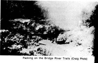
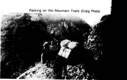
Upon visiting Bralorne and seeing the scope of one-time economic development and industrial infrastructure installed (and since largely abandoned), it is difficult to image that nearly all of it came over Mission Mountain after being shipped in by rail or boat to Shalalth (today's road from Lillooet via the Bridge River Canyon was not built until the late 1950s). The picture of freight trucks struggling with an icy slope at left doesn't tell the whole story - note the bit of road in the foreground, hinting at the sharp switchback these trucks have just manoeuvred only to become stuck on an iced-up uphill. |
||
| The picture at right is of one of the Evans Transportation Company's freight vehicles adjacent to the PGE tracks at Shalalth station; immediately to the right out of sight is the very bottom of the road up the pass. The log retaining wall at right is still there today, the office building of the transport company visible above them today serving as the band office of the Seton Lake Indian Band. Who knows how many miles of rough road this truck has seen, and how many times its brakes, suspension, and transmission have been replaced! The hump in the mountainside in the background is the slope followed by the route of the Mission Mountain Road, which is visible in places in the photo if you know what you're looking at. In summer, tell-tale trailings of dust help locals keep an eye on traffic coming into and out of the valley; at night, headlights from vehicles on the pass are clearly visible from most of the valley. The Evans Transportation Company had a virtual monopoly on freight and passenger traffic to and from the mines for decades, and its offices were one of the hubs of life in Shalalth. The picture at top right is of the Evans Co.'s other main shipping item - bags of gold concentrate, here waiting to be loaded onto the PGE for shipment to Vancouver. Bev Hurley, who worked in the Evans office for years and still lives in the Portage, told me that there were no security worries about the gold in those days - the only ways in and out of the valley were via the rail line and the lake, so it could be left unguarded until it was loaded onto the freights, sometimes for days. |  BC Archives # I-29059 |
|
 Photo: E. Cleven |
||

