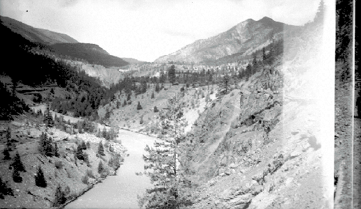
BC Archives # I-33453 View of Moha from Antoine Bluff, 1947 Photo: Frank Swannell
| In support of my webspace rental fees plleasedonate generously at GoFundMe or Patreon |
Thank
your for visiting. If you enjoy this site please make a donation. |
|
| BC Archives # I-33453 View of Moha from Antoine Bluff, 1947 Photo: Frank Swannell |
The Moha
|
 Photo: Mike Cleven |
||||||
 Photo: Mike Cleven |
Though not an actual physical entrance to an underground realm, the name for this place and object is "the Moha", and the dark stone is supposedly a gate to the underworld, "the land of plenty", from whence some first peoples say they came (though not, as far as I know, the St'at'imc but I'm trying to find the proper version of this story to correct or amend this). I don't know the particulars of the St'at'imc legend here and hope to find out and amend this text accordingly. I do know that "in the old days, there were deer people living in four large underground houses" in the Bridge River Valley over the mountain from Seton, although it was never clearfrom that story if these underground houses were mythological places (or if the deer people where a deer-clan native people of some pre-Contact historical period now unknown. Any St'at'imc person reading this who knows is more than welcome to e-mail me with the correct version). I doubt there is any connection between that story and "the Moha", but I would certainly be interested to know if there were. Certainly the locality of Moha and environs (now locally called Yalakom, but also called "Bridge River" by the local inhabitants) is more than amenable to human habitation, and might indeed have been the location of a once-large but now-forgotten ancient settlement, even as is the case with Lillooet,Seton Portage,Mt. Currie and elsewhere in the region. | ||||||
| One legend I have heard is that the benchlands adjoining the convergence of the Bridge and the Yalakom were in ancient times the site of major gatherings of native peoples from throughout the region for ceremonies lasting many weeks consisting of dance and celebration. The St'at'imc native source for this tale was an elder speaking to one of the local landowners, whom he enjoined to never sell the land and always keep it in his family, citing tradition that the lands were on a place of great power, and a source of great fortune to any that live on them, and that it was good fortune that these lands had come to the present owners. Indeed, the setting of Moha - not visible easily through the photographic lens because of its geological three-dimensionality - is a dynamic and magical place, from any of several viewpoints within the vicinity. The gorge of the Great Canyon cuts through the forested buttresses of the Shulaps Range and (severed by the Canyon from the Shulaps Range) the snowy knolls of Mission Ridge, the dark, wet winds beyond the canyon pouring out into the arid semi-desert and pine of the Yalakom and the lower valley of the Bridge. |  Photo: Mike Cleven |
||||||
|
At the junction of the Bridge and Yalakom Rivers, just upstream from the Wash through a narrow canyon, there was once (I remember) a small store or cafe with a gas pump and one lone incandescent light above a small concrete stoop. There are still houses on the site, which once had an orchard and (if I remember right) a couple of cabins adjoining the main building. At one time, this was about as far as you could come up the Bridge River from Lillooet, the violent course of the river through its Great Canyon between here and the upcountry base of the Mission Mountain Road (from Seton Lake over the mountains to the goldfields, then the only way into the upper Bridge country) making anything other than horse, packtrain or foot travel impossible. The trip by canyon trail on horseback from Moha to the upper Bridge valley - only ten miles upriver - is said to have taken 12 hours, and in some cases (due to inclement weather and/or associated river conditions) a few days. The store must have been built at the time of road construction during the canyon in 1957-8 as a roadhouse for workmen and truckers; I only remember it vaguely and don't think it looked that old (for those times); it may yet have been there in the 1970s when I first got back into the Lillooet Country - if there are any older Lillooeters out there who remember and details about the store, please let me know; maybe the store dated from the heyday of the placer and hydraulic operations in the lower Bridge River and at nearby Horseshoe Wash There was never a town at Moha, despite its appearance on maps, other than a ranch of the same name and a scattering of small local freeholds. |
|||||||
 Photo: Mike Cleven The Horseshoe Wash |
 Photo: Mike Cleven |
||||||
| The above views of the Horseshoe Wash above
were extremely dangerous to take, as I stood on the sandy lip of the
wash a few yards from the Moha Road (Hwy 40); the bottom of the wash in
the extreme wide-angle photo at left is near straight down, and the
horseshoe shape of the Wash if exagerrated. The hoodoo-like alls
of the upstream (northwest) flank of the wash are visible in the
picture at right, with the pieak of Vast Mountain
and the opening of the Great Canyon of the Bridge River in behind. The junction and
community of Moha are on the bench at right in the left-hand photo. |
|||||||
 Photo: Mike Cleven |
This is the easiest - and safest - view of the Horseshoe Wash, through which the Bridge River flows just after its convergence with the Yalakom just above the twisting canyon at upper left. Road 40, the "Moha Road" of the old times, takes a curving route around to the right of the half-mile across Wash, which was formed by hydraulic mining operations. Although the road closely follows the edge of the Wash, most other approaches are quite precipitous and involve unstable banks and ongoing erosion, so the place is best appreciated from the pull-out at its southern edge. The original landscape here was a continuation of the benchland in the top-centre of the wash, with the river confined to a steep canyon of gravel and sand. | ||||||
| The remaining canyons just above and below the wash are rocky (although toned in rich-coloured ores), however, although only visible as a result of an hour or so's hike down into the Wash, or from above or below via the river. The scale of landscape alteration here is staggering once you realize this was a mine, and it's clear that this must have been a rich operation to have gotten so big in the first place. The benchland here is all alluvium, remnants of ancient floodings and flows and full of gravelly ore from seven rich mountain ranges in the days of the Great Melt. I don't know any particulars about the company or the find or what years this was in operation (the 1870s strike a chord, but I can't remember the source) , but I'll try and dig that up if I ever get around the Assay Office or the Chamber of Mines or anywhere else useful for that kind of thing. Recent placer operations in the lower reaches of the Great Canyon of the Bridge in the few miles just above the convergence with the Yalakom turned out to have been extraordinarily rich, although the discovery was kept largely secret, with no stocks ever being offered. I guess the moral of the story is when you're making huge amounts of money daily, who needs to get investment from the stock market? The Bridge remains famously rich and is still highly regarded by mining investors, with major explorations underway in various locations around the region, and the revival of the once-great main pits of the Bralorne Mine. Hydraulic mining's not likely to be back because of environmental concerns (most of the land beyond the excavated point in the picture, by the way, being privately held and probably hostile towards resumption of hydraulic mining that would wipe out their holdings!) | |||||||
 These pictures are taken from the
northwestern tip of the Wash, but looking down the Bridge River as it flows into the Horseshoe
Wash. Both walls of the river from here nearly all the way down
to the Bridge's junction with the Fraser
at Sxetl were hydraulic mined in the second
half of the 19th Century, as indicated by the sand walls on the farther
wall of the canyon here. These pictures are taken from the
northwestern tip of the Wash, but looking down the Bridge River as it flows into the Horseshoe
Wash. Both walls of the river from here nearly all the way down
to the Bridge's junction with the Fraser
at Sxetl were hydraulic mined in the second
half of the 19th Century, as indicated by the sand walls on the farther
wall of the canyon here.Photos: Mike Cleven |
 |
||||||
 |
This view is from the south point of the
Horseshoe Wash formation, which was among the largest (if not the
largest) of the Gold Rush-era hydraulic operations, looking into a
rocky stretch just below a twisting canyon that leads out of the Wash
into the Bridge's lower reaches from its contortions at Moha.
During the Gold Rush, the area of the lower Bridge (as far as Moha) was
heavily mined by hydraulic outfits licensed by an enterprising (and
locally powerful) chief of the Bridge River ('Xwisten) Band of the St'at'imc Nation. The Bridge still gives
up records amount of gold throughout its length, including a recent
find in the lower reaches of the Great Canyon of the Bridge, even
though large stretches yet remain unexplored because of native
ownership - or because they are under the waters of Carpenter and
Downton Reservoirs. In addition to gold, hydraulic miners also
sought after molybdenum, the blue-grey ore of which is markedly visible
in places along the Bridge's banks where dozens of hydraulic mining
operations had once thrived; certain other placer metals were also
found, with there being rumours of such rareties as chromium and
pitchblende in the then-mysterious upper Bridge River Country beyond
the Great Canyon. Jade, agate and other ores were also pulled
from placer operations here, with much of the Bridge's rocky banks
lined as much by raw jade and rough agates as by granite (most of it
too big to move!). |
|
|||||
| Photo: Mike Cleven Just below the Bridge's convergence with the Yalakom at Moha, the valley opens up for six-eight miles or so in a broad, sloping basin until its next deep gorge at Applespring Bluff and the remaining miles of canyon-throat to the Bridge River Fishing Grounds and the Bridge's convergence with the Fraser. Nearly all of the land in the picture at right is part of the gigantic (for BC) Bridge River Indian Reserve, which takes in most of the flanks of the Bridge River below the convergence with the Yalakom. The snowy heights visible are not alpine, but snowed-over logging operations on the reserve. The picture is not "tilted", by the way - that's the lay of the land, not an off-centre camera. |
 |
||||||
Vast Mountain - "King of the Canyon"
|
 Photo: Mike Cleven |
| Vast
Mountain was named in recent times by one of the residents of its
lower slope, in the rural community of Yalakom/Moha. I do not
know its native name, and it remains ungazetted, despite its prominent
position within the focal alpine bends of the Great Canyon of the Bridge
River, the northwestern walls of which are the mountain's
ramparts, some precipitous 5000 feet of near-vertica clear around beyond
the Canyon along the shores of Carpenter Lake for not a few miles;
hence is name - vast, despite its relatively invisible summit.
The southeastern-most peak of the 50-mile long Shulaps Range, a series
of high tundra domes limning the northeastern flank of the upper Bridge River Basin - over which its craggy
western faces look. Vast Mountain is home to the Hell Creek jade
mine, one of BC's main sources of gem-quality jade for many years.
The outlet of the Great Canyon into the dryland Yalakom-Lower Bridge
dale is hidden behind the forest slopes in the midground of the
picture, which was taken looking up at a 45 degree angle or so just
downstream from Moha, which is just to the right. On Vast's lower
flanks near Terzaghi Dam, there are a
couple of ice-climbing routes which have been documented on-line; I
will dig out that URL and link it here for those interested.
Decomissioned mine and logging roads are traversible by hiking and (not
advisedly) by mountain biking, but animal dangers are high in the area
of the canyon, particularly in alpine areas such as Vast Mountain, so
precautions should be taken. A view of this same peak from its
southwestern side is seen at lower right, above Terzaghi
Dam, and in the aerial shot at left (looking north towards the
Camelsfoot). |
|
 Aerial pic from Photos by Kat |
 Photo: Mike Cleven |
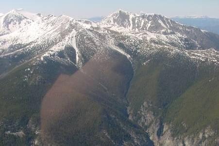 Aerial pic from Photos by Kat |
|
 Aerial pic from Photos by Kat |
|
 Aerial pic from Photos by Kat |
|
