| In support of my webspace rental fees plleasedonate generously at GoFundMe or Patreon |
Thank your for visiting.
If you enjoy this site please make a donation. |
|

| In support of my webspace rental fees plleasedonate generously at GoFundMe or Patreon |
Thank your for visiting.
If you enjoy this site please make a donation. |
|

| In the old days, the upper Bridge
River was largely unknown to non-natives except by hunters and
prospectors guided into the area by legendary big-game guide Chief
Hunter Jack of the Lakes Lillooet (today's Seton and Nequatqua/D'arcy
Bands), whose personal fiefdom and tribal territory this was. He
had a fabulously rich placer deposit, believed to be somewhere in the
Marshall or Tyaughton Lake areas, and drove out more miners than he
allowed in (more about him on the Chief Hunter Jack and Big-Game Guides
pages). In his later years he began to help certain prospectors
explore in the region, leading to the discovery of the Pioneer Mine and
the collection of claims that were to become Bralorne Mines. As
travel the mines and the communities that began to grow around them,
Hunter Jack operated a ferry across the Bridge River in the vicinity of
the area in the pictures just below, connecting the trail which led over
Mission Mountain in the days before the road was built (pre-1920s) to
the main trail to the upper Bridge River Goldfields on the north bank of
the Bridge River. |
|
 BC Archives # I-52525 |
 |
| |
|
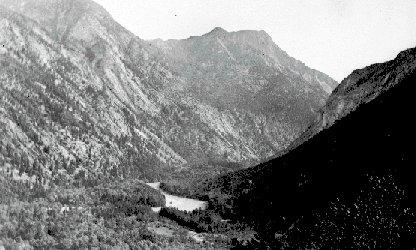
 BC Archives # NA-03796 |
I've puzzled over the location of
the photo at left, which is from the BC Archives collection.
I'm taking a guess by saying this, but I think it's the old pack trail
through the Bridge River Canyon near its
outlet at Moha; the mountain in the background
partly obscured by cloud is the hillside above Moha.
The old Canyon pack trail was a torturous
affair, and took a whole day or more to traverse the 10 miles from Moha
to where the valley opens up above where is now Terzaghi
Dam. The BC Achives caption says "trail up the N. Fork of the
Bridge River" but I'm not certain what that means. The North Fork
of the Bridge River would be from where the South Fork - the Hurley
River - branches off near Gold Bridge,
but this doesn't look like that area, either in vegetation or terrain;
it looks much more like the Moha area; but around there the "north fork"
of the Bridge River would be the Yalakom River, and easier trails could
be found on that stream's north bank and wouldn't look like this.
Any locals who might recognize this location are welcome to contact me (replace "_at_" in address with @ symbol) to correct this guesswork. |