Aerial pic from Photos by Kat
| Webspace generously donated by synercom/edi |
Thank your for visiting.
If you enjoy this site please make a donation. |
|

In the wider canyon vale that runs south from Lillooet to Boston Bar where, the valleys of the Cayoosh, Seton, Blue Pavilion and other creekswatersheds within a range of the canyonland's focus at Lillooet and Fountain. The great complex of gorges and alpine that is the basin of the Bridge River, once near-legendary even in modern times for its unique remoteness and stunning beauty, runs some 120 miles from the great Lillooet Icecap in the central Coast Mountains through a spectacular series of basins and canyons to its confluence with the Fraser; its middle canyon, downstream from Terzaghi Dam to the Yalakom's merger with the Bridge at Moha, is a staggering gorge of towering 5000' cliffs closed in on a narrow, rocky rivercourse strewn with giant boulders of jade and variegated granite. The Bridge's lower canyon below Moha and Horseshoe Wash to the Fraser is now dry of most of its natural waterflow, but still has stunning stretches of deep pools and jade-coloured rapids running beneath steep canyon walls, flanked on all sides by soaring mountain flanks and glimpses of high alpine. The Yalakom River's canyon upstream from Moha is relatively short but incredibly narrow The largest of the upper Bridge River canyons is that of the Hurley River, also called 'the South Fork' [of the Bridge], views of which visitors are treated to on the main road between Gold Bridge and Bralorne, the canyon's east wall where the road runs being about 2500' above the river, although it's only about eight miles long from Hurley Falls below Bralorne to its confluence with the main course of the Bridge at Haylmore (a 'suburb' of Gold Bridge). The lower canyon of Gun Creek runs some thirty miles, and though it is not of great depth is fiercely rocky, filled with the creek's powerful waters.
[MAP}bridge-marble.gif

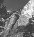
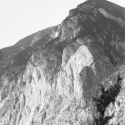
Photo: Mike Cleven This is among the most historically famous of the great scenic views of the Lillooet Country: the view north up the Fraser Canyon from the 12 Mile Roadhouse at Fountain. Travellers from farther south along the Fraser were forced by geography to detour through Fountain Valley in order to get to Lillooet or (before the construction of the Lytton-Clinton stretch) in order to reach the Cariboo Wagon Road for the journey north; this was the view that greeted them as they descended to the Fraser. For a few months in 1858-9, Fountain was nearly as famous and busy a staging ground for the Gold Rush as Lillooet. The ruins of the 12 Mile Roadhouse adjoin the site of this roadside view, which lies along the original route of the Wagon Road through the Fraser Canyon's grandest stretch. What is not easily evident from this roadside view is the depth of the Fraser's gorge at Fountain. The canyon walls seen here only constitute the deepest level of a multi-layered canyon that cascades down from alpine heights on either side, some 4-7000 feet of vertical above the river (elev. c.1000'), depending on which of the many summits about Fountain the measurement is takenl. The eastern flank (up to the right; see below) is actually a plateau edge of high, flat summits known as the Clear Range. From the highway it appears to be a line of peaks, and may be fairly easily accessed by a mix of road and hiking from the Hat Creek basin and the south wall of Marble Canyon. The left wall at this point is a spearhead-shaped ridge that is the last abutment of the 80-mile Camelsfoot Range, named for camels brought in during the gold rush, some of whom reputedly ran wild in the montane deserts of central BC (of which the Camelfsoot Range is typical). Camelsfoot Point is the name of the 7000' summit immediately above the southward point of the Fraser's bend at Fountain, and is itself only the foreshoulder of 9000+ Camelsfoot Peak in behind. In the view shown, this is the bank at left; the summit in the background is actually only a low forehill of the Camelsfoot and Black Dome Ranges and the plateaux in behind; the Fraser comes from to the right of it.
|
|
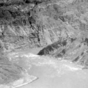
| Six Mile Rapids, Fountain BC
|
 Photo: Mike Cleven |
 BC Archives # A-06133 |
|
| Other Interests & Creations | |
||
 Chinook Jargon |
 Poetry & Other Writings |
||
 Family History Winnipeg, Montreal, Halifax, Pat Bay, Ft. McLeod, Lillooet, Mission, Norway, Los Angeles and more |
(links/pages added
soon) Acting |
||
 |
|||