| In support of my webspace rental fees pllease donate generously at GoFundMe or Patreon |
Thank your for visiting.
If you enjoy this site please make a donation. |
|
| Gold
Bridge |
Bralorne-Pioneer |
Mission Mountain Road |
||
| Minto City |
Brexton |
 BC Archives # D-03831 |
 BC Archives # F-07583 |
 BC Archives # A -09595 |
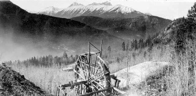
The Bridge River Country remained virtually unexplored by non-natives until near the end of the 19th Century, its mountainous ramparts and canyoned gates keeping out idle adventurers as well as the many, many prospectors who would otherwise have explored the valley for the motherlode of Fraser placer gold that was believed to lie in the Bridge River headwaters. Even today the difficulty of physical approach to the valley helps preserve tits isolation to a certain degree, despite the building of new roads into the district via the Bridge River Canyon and Railway Pass in addition to the old goldfields road via Mission Pass from Shalalth. But also keeping out prospectors and settlers rather more directly than mere physical obstacles was Chief Hunter Jack of Shalalth, who claimed the valley as his own and is said to have been promised it as his personal domain during a visit by British Admiral Seymour in the 1870s, who was one of his many high-class outfitting clients. Hunter Jack's legendary placer mine was said to be in the Bridge River Country, which was the reason he so jealously protected his territory from prospectors and what would follow, although certain individuals such as Arthur Noel and Lazack Lajoie took up these activities in the time of Hunter Jack's dominion over the valley, which ended by his death at Seton Lake under mysterious circumstances c.1919. The cabin at top left is said to have been the earliest built in the upper Bridge River basin and was located in the Gun Creek area, near Minto City. As it is rough-built in the Indian style, it was likely of Hunter Jack's own construction - unless it was one of the cabins of first non-native settler, Lazack Lajoie, although his residence was supposed to be over by Little Gun Lake. Hunters and prospectors in the valley had to pay their respects to Hunter Jack, if they were tolerated at all - and many were not. During the gold fever in the region surrounding the development of the Golden Cache Mine at Lillooet in 1898, a new wave of prospecting talent began to roam into the area, which was barely on the map for the first time - literally; older maps show rough-drawn lakes and little more, based on hearsay but no actual surveys. Placer rewards were rich in the region, but ultimately investigations of hard rock potentials had spectacular results. The picture at upper left is of the first drift of the Lorne-Pioneer Mine in 1898 on the banks of Cadwallader Creek, which was the foundation of the huge Bralorne-Pioneer Mine complex for which the valley became famous. Pictures further below are of the main stope and entrance portal of the Bralorne Mine, which was developed in the 1930s a few miles downstream from the original Pioneer Mine, major development of which had taken place just prior to the onset of World War I. Bralorne's wealth was vast - three hundred and seventy million 1930s dollars in half a dozen years, and it kept on producing until 1971 when it was shut down due to engineering difficulties concerning the mine's increasing depth - over a mile below sea level, from an entry at 3400' above. It has recently been re-opened because of engineering advances in the region, as well as changes in gold markets and resurveying of the subsurface geology in the region. |
 BC Archives # C-08635 |
|
 BC Archives # C-08637 |
|
 BC Archives # I-29085 |
 I was curiously elated to find
this picture in the BC
Provincial Archives. It's not a remarkable building, nor is
it very old. It's not even standing anymore, having burned
down around 1984 in a middle-of-the-night furnace explosion.
But the Mines Hotel was imbued with the spirit of the Bridge River
goldfields country until its very end, and perhaps better than
anywhere else in the rambling ghost-town gave visitors a taste of
what life was like during the heyday of the Bridge River mines.
Located between bends in the canyon road just outside Bralorne's
company-town limits, the Mines was the closest bar to thousands of
hungry miners, who dubbed it "the Main Stope". In tribute to this
name, above the mock hearth in the bar (there was no fireplace per se)
was a toy mine, with miniature carts and miners with pickaxes, rock
crushers, and sluices. Innumerable business deals were struck
here, and nearly anyone who ever visited or lived in the Bridge River
country passed through its doors. The view from the plain front
stoop was incomparable - the green slope of the forested Noel Range
immediately opposite, with Mt. Sloan towering off to the right.
Like thousands of others, I have sharp memories of standing outside
the Mines, both drunk and sober, on hot summer days and stellar autumn
nights, taking in the mountain scenery and the rich flavour of the
place. I don't think there was a bar like it anywhere in the
world, not even in the rest of the Bridge River Country. I stayed
in one of its plain 1930s-era rooms about a year before it burned down
- actually the one just to the left of the fire escape - a privilege I
will always cherish, as well as remember with some sadness for the
loss of this seedy but wondrous old miner's bar.
I was curiously elated to find
this picture in the BC
Provincial Archives. It's not a remarkable building, nor is
it very old. It's not even standing anymore, having burned
down around 1984 in a middle-of-the-night furnace explosion.
But the Mines Hotel was imbued with the spirit of the Bridge River
goldfields country until its very end, and perhaps better than
anywhere else in the rambling ghost-town gave visitors a taste of
what life was like during the heyday of the Bridge River mines.
Located between bends in the canyon road just outside Bralorne's
company-town limits, the Mines was the closest bar to thousands of
hungry miners, who dubbed it "the Main Stope". In tribute to this
name, above the mock hearth in the bar (there was no fireplace per se)
was a toy mine, with miniature carts and miners with pickaxes, rock
crushers, and sluices. Innumerable business deals were struck
here, and nearly anyone who ever visited or lived in the Bridge River
country passed through its doors. The view from the plain front
stoop was incomparable - the green slope of the forested Noel Range
immediately opposite, with Mt. Sloan towering off to the right.
Like thousands of others, I have sharp memories of standing outside
the Mines, both drunk and sober, on hot summer days and stellar autumn
nights, taking in the mountain scenery and the rich flavour of the
place. I don't think there was a bar like it anywhere in the
world, not even in the rest of the Bridge River Country. I stayed
in one of its plain 1930s-era rooms about a year before it burned down
- actually the one just to the left of the fire escape - a privilege I
will always cherish, as well as remember with some sadness for the
loss of this seedy but wondrous old miner's bar.
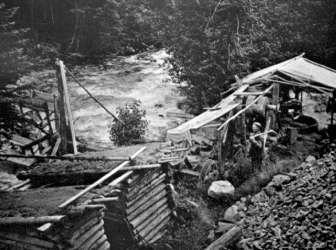
 The
famous "Arrastra", or water-driven rock-crusher, today lies on its
side in the undergrowth but was a noted symbol of the Bridge River
goldfields for many years, dating from the earliest years of the
mine's workings (which is why I chose its picture and setting for the
top of this page. During the first eight years of the mine's opening
in the early1930's, the value of the gold ore extracted was over
$370,000,000, and the extraordinary quality of the ore - rock quartz
studded with huge nuggets - was without equal. Engineering difficulties
to do with the mine's increasing depth led to its closing in 1971,
although advances in technology and changes in world gold markets
have led to the mine's recent re-opening. During its heyday,
Bralorne-Pioneer was the largest town in the Squamish-Lillooet
Regional District with around 10,000 residents (more than today's
Lillooet). Both these photos are postcards by pioneer photographer
Artie Phair; the picture on the left is of the main mine buildings and
the "first townsite" of Bralorne's chain of three that extend up the
Cadwallader Valley to Pioneer. The view of the arrastra featured at the
top of this page, with Mt. Sloan and the Frost Fiend behind (Bralorne
is immediately below), and is perhaps the most evocative image of the
old rock-mill:
The
famous "Arrastra", or water-driven rock-crusher, today lies on its
side in the undergrowth but was a noted symbol of the Bridge River
goldfields for many years, dating from the earliest years of the
mine's workings (which is why I chose its picture and setting for the
top of this page. During the first eight years of the mine's opening
in the early1930's, the value of the gold ore extracted was over
$370,000,000, and the extraordinary quality of the ore - rock quartz
studded with huge nuggets - was without equal. Engineering difficulties
to do with the mine's increasing depth led to its closing in 1971,
although advances in technology and changes in world gold markets
have led to the mine's recent re-opening. During its heyday,
Bralorne-Pioneer was the largest town in the Squamish-Lillooet
Regional District with around 10,000 residents (more than today's
Lillooet). Both these photos are postcards by pioneer photographer
Artie Phair; the picture on the left is of the main mine buildings and
the "first townsite" of Bralorne's chain of three that extend up the
Cadwallader Valley to Pioneer. The view of the arrastra featured at the
top of this page, with Mt. Sloan and the Frost Fiend behind (Bralorne
is immediately below), and is perhaps the most evocative image of the
old rock-mill: 
 Photo: Artie Phair Postcard |
Once known as the "Queen of the Bridge River Country", Mt. Sloan is one of the principal peaks of the Bridge River goldfields, standing at the head of the main part of the upper valley and reminiscent of the Matterhorn as one approaches up Gold Bridge along Carpenter Lake. Standing as the last peak in the promontory of mountains between the Bridge River and the "South Fork" of the Bridge (properly known as the Hurley River), Sloan dominates the view in Bralorne and Gold Bridge as well as nearby Gun Lake. This view was taken by pioneer photographer Artie Phair from the summit of Greenmount, or Green Mountain, a grassy dome a couple of thousand feet lower than Sloan's 9790 ft. which was once road-accessible because of the old fire lookout there. Immediately above in the section on the Old Arrastra is another view of Mt. Sloan, from considerably to the left of the above image. Other views of Sloan and the other major peaks and ranges of the Bridge River Country will eventually be posted here..... |
 This picture for a while now I've attributed to the Bendor Range; upon fiddling with the contrast a bit to bring up the relief I realize this seems to be the view of Frost Fiend from a few miles up the Hurley from the Crossing; Bralorne would be over to the right, Mt. Sloan in behind the Fiend, which is the central of the three knolls apparent here, but actually over 9000 ft in height (the valley here would be c.3000). Older views of the Hurley Range are pretty rare - the road out even this far was well-out-of-the-way during Dad's time up there. It's a fairly common sight today for a good chunk of the Bridge River Country's visitors, who drive this route up from the Coast during the few months a year the road is open. |
 BC Archives #G-00618 |
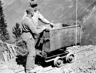
Not all the mining activity in the region was monopolized by the big companies. The picture above is representative of the many smaller outfits, both hard-rock and placer, which made the region a dynamic one for small miners and venture prospectors - who still can be found at workings in hidden bits of the basin. I'm not sure where the Red Hawk Mine was, but by the look of the mountainside in behind I'm guessing it to be high up on the sides of the Piebiter or Hawthorne Creek drainages upstream from Pioneer (I'll check this later). |
![]() The Mountains of the
Bridge River Country
The Mountains of the
Bridge River Country
Mt. Sloan
Mt. Dickson
Hurley Range
The Bendor


