| In support of my webspace rental fees plleasedonate generously at GoFundMe or Patreon |
Thank
your for visiting. If you enjoy this site please make a donation. |
|

BC Archives # I-57558
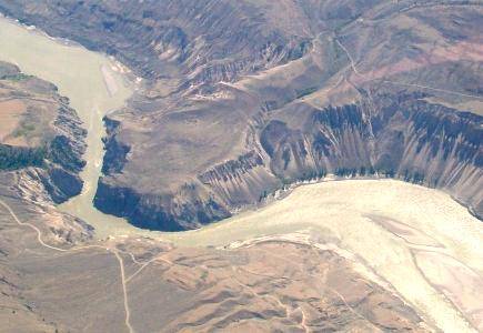
Aerial pic from Photos by Kat
|
||||
| Big Bar & Big Bar Canyon |
|
|||
| BC Archives # I-57558 |
Aerial pic from Photos by Kat |
|||
| The higher profile of areas
upriver from Moran in gold rush times is a reminder that only wheeled
travel - wagons and stages - needed to use the road, and that
non-wheeled travel could use the Canyon route instead and many did; it
was shorter but much more scarce on water and the system of roadhouses
available along the Cariboo Road, however.... |
|
|
|
|
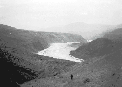
Big Bar Canyon |
|
|
|
This picture of Big Bar Canyon, about 60
miles upstream from Moran, was probably taken for hydroelectric
survey purposes, or for railway surveys for a riverside route that
was never used; there's usually a good (industrial) reason isolated
bits of BC landscape wind up in the government archives, government
photographers rarely shooting for their own enjoyment. The
Canyon here is obviously not as high nor the river as rough as in the
Fountain-Pavilion-Moran region, but as you can see it's every bit as
arid and challenging, although the severe dryland of the Canyon's depth
is narrower here, with relatively verdant plateau forest limning the
Canyon edge, as seen here. |
 BC Archives # I-57872 |
 |
 BC Archives # I-22450 |
 BC Archives # I-57872 |
| The building at left was Phil
Grinder's hotel and post office and dates from the time when the Canyon
trails were still a major route of travel between Lillooet and the
Cariboo.and Big Bar was a relatively busy place. The picture at
right is typical of the rangeland valleys which cut into the Cariboo
plateau in the Big Bar area. |
|
 Aerial pic from Photos by Kat |
 Aerial pic from Photos by Kat |
| I'm uncertain of the location
depicted here, which is somewhere between Moran and Dog Creek; I think
it's south of Big Bar as there are still mountains flanking the canyon
instead of plateau. |
|
The
scale of the Fraser's Grand Canyon is hard to appreciate, even when
journeying through it (as spectacular as that drive is). Only by
climbing to the moutainous heights on either side of the canyon can
its depth and vastness be appreciated. At Fountain, where the
Fraser does a torturous double-reverse 's' bend in a one-mile
radius, the mountain peaks on either side tower between 7000 and
5000 feet above the river; just upstream in the Glen Fraser area
both sides are well above 7000 feet, and at Moran (just north of
Pavilion), it is more like 8000. The highway and rail line
through this section (they could not follow the river further
upstream because of the canyon's steep sand walls) follow the
benchlands at the first level above the river, limning the deeper
level of canyon walls, which themselves are between 1000 and 2000
feet sheer to the river. The first two pictures in the
following set are of the Fountain Canyon, the former being slightly
upstream from the latter, which is taken at the point where the Fraser
turns north briefly before turning south again a couple of miles
later. The next three pictures were taken from mountain
heights in the Pavilion area, and give an idea of the canyon's
tremendous depth and aridity. The next two are of the Moran
Canyon section, where the BCR (the old Pacific Great Eastern railway)
was forced to turn into a side valley rather than follow the Fraser
north; Moran has long been debated as a site for a major hydroelectric
project on the Fraser that would create a lake stretching a couple
of hundred miles north to Williams Lake, flooding the upper reaches
of the Grand Canyon and destroying what is left of the Fraser salmon
fishery. The last picture is of the canyon in the area of Big
Bar Ferry, and is typical of the miles of similar country that lay
between Moran and Williams Lake, where the highway and rail line are
at ;ast able to rejoin the Fraser. Travel through the Big Bar
country is difficult and often dangerous, and traverses the legendary
ranch country of the Imperial Valley and Gang Ranches.