BC Archives # I-22336
|
Just
north beyond Moran, the rail line cuts through a cleft in the Marble
Range through a small ranching settlement known as Arden Forest, and
then on to Kelly Lake, rejoining the route of the northbound Cariboo
Road at the base of the Pavilion Mountain Road. All the
black-and-white pictures here are courtesy the British Columbia
Archives; those I hope to add in future will be in colour. Moran
is well-known to hydroelectric engineers as the potential location of
what could have been one of the largest dams in the province, although
government policy has now moved away from reservoir-type hydroelectric
developments towards less environmentally harmful sources; if ever built
the resulting lake would stretch north beyond Williams Lake as well as
some distance up the Chilcotin River;
damage to the Fraser fishery, siltation and changes to the climate and
biogeography of the Cariboo-Chilcotin were among the reasons the
project was never built, despite several attempts to push it by
politicians and Hydro officials (as with the Hat Creek Power Project).
Other dams in the same much-dreamed-of project would be at Glen Fraser-Fountain and at Lillooet Canyon,
just above the town of Lillooet, which would have flooded out the Six
Mile Rapids Fishing Grounds and backed the Fraser up past Fountain
Rapids; Glen Fraser would have been just above that. Needless to
say, the effect of any one of these dams on the Fraser fishery would be
devastating, which is why there is a standing moratorium on further
damming of the Fraser and its tributaries (the Nechako having been
already heavily impacted by the Kitimat-Kemano hydroelectric-aluminum
smelter development); the extremely high dam at Moran - 3000' - would
be simply too high for any fish ladder system to be considered.
And in addition to the very serious loss of the remaining upper Fraser
fishery, one of Canada's grandest and (though-forgotten) historic
stretches of desert scenery would be lost forever, even though it's
largely invisible to the public eye today because most travel goes via
other regions nowadays due to the lack of paved roads and services in
the area. From Moran north to Williams Lake, the Fraser is only
touched by difficult 4x4 ranch and forestry roads, with almost
nothing in the way of services other than small cable ferries and
the occasional gas pump and store here and there at High Bar, Big Bar and Gang
Ranch-Dog Creek. If you ever decide to drive up this way by
any of the routes, remember to bring lots of gas - and water. |
 |
BC Archives #
H-00643
|
|
|
|
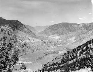
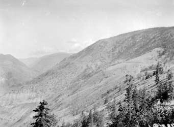
The two pictures at right correspond
to each other closely; the lower picture is taken from near the first
"point" on the rail line in the picture at right, looking over the
shoulder of the ridge at far left up the Fraser. For good measure
and to give a good idea of the scale of the terrain in these views, the
picture below is the full size one from which the picture at right was
cropped, and shows how far below the Fraser is, and how much more severe
desert-like the country is as you get towards the canyon bottom.
The climate of the rangeland and higher mountain areas is
obviously much wetter, though many of the creeks that form on the
benchland do not reach the Fraser, clearly shown in both of the pictures
in the next row.
|

Aerial pic from Photos by Kat
|
|
|
|

Aerial pic from Photos by Kat
|

BC Archives # NA-04639
|
|
|
|

BC Archives # H-00639
|
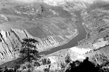
This is another northward view from
the rail line. If I'm not mistaken (it's been years since I've
been up the rail line that far) the valley visible at far right in
this photo is the gap in the Marble Range that the line takes towards
Clinton via Arden Forest-Kelly Lake; the
benchlands at centre-left are, I think, those featured in the centre
of the other photo. The mountain in the far distance at centre
left - and mountain it is, despite its seeming hillishness, is China
Head, one of the eastward flanks of the Camelsfoot Range, now a
favourite area for 4x4 enthusiasts in search of high alpine roads to
conquer. Roads from China Head lead to Big Bar Ferry, a
native-operated cable-drag raft open only part of the year (and when the
locals are around to run it) that connects back via Jesmond to Clinton,
as well as further north along the Fraser to Gang Ranch and Dog Creek.
The view on the right is from the PGE line as it emerges from the
narrow gulch connecting the Kelly Lake area to the Fraser Canyon; the
rail line curves away to the left from here towards Lillooet.
|
|
|
|
|

BC Archives # H-00641
|
BC Archives #
I-22330
|
|
This view gives a good idea of the
general lay of the track from Pavilion to Moran - one long grade cut
into the side of a rocky scree. The grade is actually fairly
steep and very tough on the engines, the whole ascent from Glen
Fraser to Moran and Arden Forest being as far as I know the largest
hill on the whole of the BCR mainline. Only one other surveyed
route to the Interior available to the BCR - Railway Pass from Pemberton into the upper Hurley River - would
have surpassed it in the distance climbed and the grade, had it ever
been built, with a grade beginning near Pemberton and progressing 50
miles to the summit of Railway Pass; the distance from Lillooet to Moran
is only about 30 miles, and the ascent is only 3500' or so
[check]. In the vicinity or Moran the train generally slows down;
not only so passengers could get a good ogle of the depths of the Fraser
Canyon far below, but also because of the instability of the slope and
the likelihood or rock on the track. I think every time I've
been along this stretch there's been a work crew in the area, a sign
that ongoing work is needed to keep the railway open in this area due
to ongoing erosion and small landslips.
|
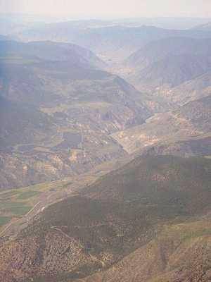
I'm not sure of the actual track
mileage of this photo, but it seems close to the final mile or so of
the Moran Canyon stretch of the BCR, which just
north of here will duck to the right into a gap in the mountainside,
entering the (much greener) Arden
Forest-Kelly Lake Valley, which leads towards Clinton. This
view is looking north up the Fraser towards High Bar; some of the
benchlands in this view are or were part of the Blue Mountain Ranch,
also known as West Pavilion, which was also for a while part of the
holdings of the ranchlands once known as "Carson's Kingdom", now part
of the Pavilion-Termuende Ranch. This photo gives a really good
idea of the incredible aridity and sparse vegetation of the
landscape here, which is typical of the Fraser from Lillooet to
Williams Lake.
|
|
|
|
|
|
|
|


